Over the past decade, there have been increased activities around mineral exploration and production. International Organizing Committee for the World Mining Congresses accounts that the world’s mining production has increased by 7.2 billion metric tons (BMT) in 1985 to 16.9 BMT in 2016. Moreover, due to rising demand and scarcity of these minerals at shallow depths, exploration is gradually moving to greater depths. Searching for minerals deeply seated in the subsurface has led to the increasing use of seismic and borehole geophysical methods in mineral exploration. Interestingly, these two geophysical methods were initially developed for the petroleum industry, and despite being expensive to implement, they now have growing importance in the search of minerals.
Seismic Surveys – An image of the Subsurface.
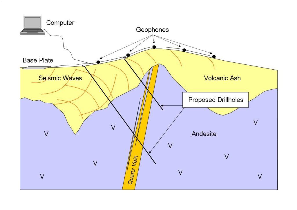
Seismic surveys provide what is likened to a pictorial distribution of the subsurface structure and stratigraphy. The method involves the propagation and measure of artificial acoustic waves into the earth. This method works by differentiating rocks based on their “seismic impedance”. This is the product of velocity (v) and density (ρ) of each rock layer in the subsurface, implying that each rock has its own characteristic impedance. As waves progress through the layers beneath the earth, some of its energy are reflected or refracted at the interface or impedance boundary between different rock types. The remaining are transmitted through the underlying formation, and the whole process repeats itself as other rock layers are subsequently encountered.
Usually, a survey design is done by generating sound waves using seismic sources such as striking a sledge hammer on a metal plate (for land survey) or using air gun (for marine survey). Receivers (called geophones for land survey and hydrophones for marine survey) are then used to collect information on reflected or refracted waves. Information gathered on the waves are processed to improve their signal and presented in a form that can be interpreted.

For mineral exploration, seismic methods are increasingly used to search for base metals, gold and massive sulfides, as an aid for monitoring geologic hazards and mine planning. The merits this method affords beats the high financial cost implication. It provides a larger lateral view and 2-dimension or high 3-dimensional resolution of geologic structure in which minerals are hosted at greater depths, and in some cases, it can serve to directly indicate the presence of minerals. Countries such as Canada, now having growing importance in the use of seismic method for mineral exploration. A typical example is the exploration for uranium deposits near unconformity zone separating clastic sequence from a metamorphic crystalline basement in the Athabasca Basin. In Finland, seismic survey has also been used to plan a 2.4km deep-drilling program around Outokumpu massive sulfide site. More recently, Ahmadi (2015), applied seismic reflection method to explore for sulfide deposit of a polymetallic nature. Other countries where seismic method has been significantly used include South Africa and Australia.
Borehole Geophysics – Ground-Truthing
Borehole Geophysics is the deployment of geophysical sensing tools into a drilled hole. The sensing tool which is attached to a cable, provides measurement of nearby rock properties in the drilled hole, and sends the information via the cable to a control system unit on the surface where the data is collected and kept for further processing. In petroleum exploration, this method provides a “ground-truth” follow-up to larger geophysical surveys. Instruments interact with rocks in close vicinity, and can provide detailed information on properties such as rock type, permeability, density and velocity.
Borehole or downhole methods are of two distinct varieties: borehole seismic and wireline logging. The former is achieved when seismic receivers are used to acquire information in the borehole, presented as a vertical seismic profile (VSP). VSP in most cases, is integrated with surface seismic information. A successful example of this method is the use for mine planning, and harnessing deposits of uranium in northern Saskatchewan, Canada. Conversely, the latter is when a logging tool called ‘sonde’ is used in the vicinity of the borehole. The information obtained are presented as Logs; a plot of the measured physical property versus depth. In a basic sense, well logs help to identify and quantify minerals.
Common examples of well logs utilized for mineral exploration are:
Gamma Ray Log
The log accounts for the naturally occurring gamma ray radiation from rocks or mineral. Thereafter, the gamma ray counts are interpreted in terms of lithological property.
Acoustic Borehole Imager
This log provides a full coverage of the surveyed borehole wall using pulsed acoustic energy.
Density Log
It provides measures of the average density of the formation (i.e. rock & fluids combined). In most cases, the density log is interpreted to give information about the porosity, fluid type and fluid saturation.
Caliper Log
The log measures the size and shape of the borehole. It is mostly used for lithological identification and correction of other logs

Thinking Outside the Box
In 2012, wireline logs were used for the pre-feasibility study of the Jadar Lithium deposit in Serbia, which is thought to be one of the world’s largest deposits of lithium. They have also been used in Germany for planning a lignite coal mine. In Europe, the gamma ray log was use to delineate and calculate thicknesses of coal seams.
Seismic and borehole methods are becoming important in the mining sector; conversely, the cost of implementation could limit their use. But when it comes to having detailed geological knowledge of the mineral resources to be explored, integrating these methods could immensely increase the chance of success.
Further Reading
- Ahmadi, O. (2015). Application of the Seismic Reflection Method in Mineral Exploration and Crustal Imaging: Contributions to Hardrock Seismic Imaging (Doctoral dissertation, Acta Universitatis Upsaliensis).
- International Organizing Committee for the World Mining Congresses (2018, October, 5). World Mining Data 2018: Iron and Ferro Alloy Metals, Non-Ferrous Metals. Precious Metals. Industrial Minerals, Mineral Fuels (PDF File). Federal Ministry of Sustainability and Tourism Stubenring 1, 1010 Vienna.
- Malehmir, A., Maries, G., Bäckström, E., Schön, M., & Marsden, P. (2017). Developing cost-effective seismic mineral exploration methods using a landstreamer and a drophammer. Scientific reports, 7(1), 10325.
- Malehmir, A., Durrheim, R., Bellefleur, G., Urosevic, M., Juhlin, C., White, D. J., & Campbell, G. (2012). Seismic methods in mineral exploration and mine planning: A general overview of past and present case histories and a look into the future. Geophysics, 77(5), WC173-WC190.
- Wolfram Felfer (2015). Selected Mining Applications of Borehole Geophysics. (PDF) Minex Central Asia
- Wondimu, H. D., Mammo, T., & Webster, B. (2018). 3D joint inversion of Gradient and Mise-à-la-Masse borehole IP/Resistivity data and its application to magmatic sulfide mineral deposit exploration. Acta Geophysica, 1-15.
- Jadar Lithium Deposit – Rio Tinto (Website)
Subscribe for Email Updates

